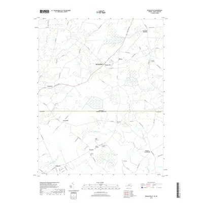
2019 Map of Whaleyville
USGS Topo · Published 2019About this map
The swampy lowlands of the Virginia and North Carolina border define this 2019 survey, where the independent city of Suffolk meets Gates County. Small, long-standing settlements like Whaleyville, Drum Hill, and Wiggins Crossroads are scattered across a landscape dominated by extensive wetlands, including Duke Swamp and Goodman Swamp. The geography is notable for its numerous family-named burial sites, providing significant value for genealogical research. Sites such as the Speight Josher Family Cem, John T Cross Family Cem, and James H King Cem are preserved among the fields and woods. An Old Rail Bed near Hazelton and Willeyton marks the path of former local transit, while the unique terrain of the Black Mingle Pocosin and Hall Pocosin highlights the distinct coastal plain ecology of the region.
Find a feature on this map
73 named features on this map. Tap any name to fly to it.
Don’t see what you’re looking for? This feature index may not catch every label — zoom into the map to look around manually.
Map Details
Editions of this 2019 Whaleyville Map
This is the sole edition of this map. No revisions or reprints were ever made.
Other maps of this area

1906 · Beckford
USGS Topo · 1:48,000

1907 · Beckford
USGS Topo · 1:62,500

1908 · Winton
USGS Topo · 1:62,500

1919 · Suffolk
USGS Topo · 1:62,500

1920 · Holland
USGS Topo · 1:62,500

1940 · Beckford
USGS Topo · 1:62,500

1943 · Holland
USGS Topo · 1:62,500

1953 · Norfolk
USGS Topo · 1:250,000
1954 · Buckhorn
USGS Topo · 1:24,000

1954 · Corapeake
USGS Topo · 1:24,000