
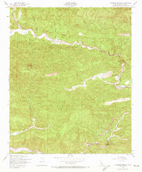
1943 Map of Wheeler Springs
USGS Topo · Published 1960About this map
Los Padres National Forest dominates this mid-century landscape, characterized by the winding path of Sespe Creek as it carves through Sespe Gorge. The survey, based on 1942 aerial photography, captures the interior Ventura County backcountry during World War II, showing a network of remote outposts and ranching operations. Human presence is concentrated around water and transit routes, with landmarks like Fell Ranch and Hartman Ranch providing rare points of private habitation within the federal forest lands.
Find a feature on this map
15 named features on this map. Tap any name to fly to it.
Don’t see what you’re looking for? This feature index may not catch every label — zoom into the map to look around manually.
Map Details
Editions of this 1943 Wheeler Springs Map
2 editions found
Other maps of this area

1903 · Santa Paula
USGS Topo · 1:62,500

1903 · Mt. Pinos
USGS Topo · 1:125,000

1904 · Ventura
USGS Topo · 1:62,500

1941 · Ventura
USGS Topo · 1:62,500

1942 · Santa Paula
USGS Topo · 1:62,500

1942 · Wheeler Springs
USGS Topo · 1:24,000

1943 · Rancho Nuevo Creek
USGS Topo · 1:24,000

1943 · Old Man Mountain
USGS Topo · 1:24,000

1943 · San Guillermo
USGS Topo · 1:24,000

1943 · Lion Canyon
USGS Topo · 1:24,000