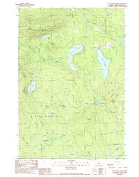
1989 Map of Whetstone Pond
USGS Topo · Published 1989About this map
Kingsbury Plt and Blanchard Plt define this interior Maine landscape during the late 1980s, an area where the topography is dominated by prominent elevations like Russell Mountain and Foss Mountain. The drainage pattern is complex, with Whetstone Pond and Piper Pond serving as central water bodies connected by a network of smaller flows, including Thorn Brook and Bennett Brook. This region of Piscataquis County retains its character as a timber and recreation corridor, evidenced by the Boat Ramp on Whetstone Pond and the numerous brooks that feed into the Piscataquis River and Kingsbury Stream.
Find a feature on this map
30 named features on this map. Tap any name to fly to it.
Don’t see what you’re looking for? This feature index may not catch every label — zoom into the map to look around manually.
Map Details
Editions of this 1989 Whetstone Pond Map
This is the sole edition of this map. No revisions or reprints were ever made.
Other maps of this area

1933 · Guilford
USGS Topo · 1:62,500

1937 · Guilford
USGS Topo · 1:62,500

1948 · Kingsbury
USGS Topo · 1:62,500

1950 · Kingsbury
USGS Topo · 1:62,500

1950 · Sebec Lake
USGS Topo · 1:62,500

1951 · Greenville
USGS Topo · 1:62,500

1954 · Millinocket
USGS Topo · 1:250,000

1958 · Millinocket
USGS Topo · 1:250,000

1960 · Millinocket
USGS Topo · 1:250,000

1975 · Kingsbury NE
USGS Topo · 1:24,000