
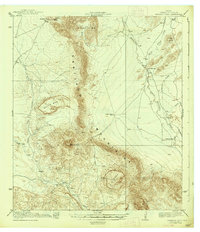
2010 Map of Whirlwind Spring
USGS Topo · Published 2010About this map
Calamity Creek cuts a path through this section of Brewster County, defining the drainage patterns of an arid landscape where water sources dictate human presence. The established Kokernot Ranch serves as a primary landmark in the north, while the southern reach is marked by Cobas Windmill, an essential piece of ranching infrastructure. Steep relief is found along the western edge at Bear Canyon and Dark Canyon, features that create natural corridors through the terrain. The presence of Whirlwind Spring underscores the historical and practical importance of isolated water points in this high-desert environment, where seasonal flow and permanent springs supported the sparse network of cattle operations and rural homesteads into the twenty-first century.
Find a feature on this map
6 named features on this map. Tap any name to fly to it.
Don’t see what you’re looking for? This feature index may not catch every label — zoom into the map to look around manually.
Map Details
Editions of this 2010 Whirlwind Spring Map
This is the sole edition of this map. No revisions or reprints were ever made.
Other maps of this area

1895 · Alpine
USGS Topo · 1:125,000

1917 · Santiago Peak
USGS Topo · 1:62,500

1917 · Buck Hill
USGS Topo · 1:62,500

1918 · Bone Spring
USGS Topo · 1:125,000

1918 · Buck Hill
USGS Topo · 1:62,500

1918 · Santiago Peak
USGS Topo · 1:62,500

1920 · Monument Spring
USGS Topo · 1:62,500

1921 · Monument Spring
USGS Topo · 1:62,500

1925 · Buck Hill
USGS Topo · 1:62,500
1938 · Santiago Peak
USGS Topo · 1:62,500