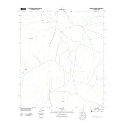
2012 Map of Whirlwind Spring
USGS Topo · Published 2012About this map
Kokernot Ranch serves as a primary human landmark in this high-desert landscape of western Texas. The ranching economy here is tied closely to scattered water sources and seasonal drainages, as evidenced by the Cobas Windmill located in the southern portion of the quadrangle. The topography is defined by dramatic elevation changes, including the massive Kokernot Mesa and the deeply cut paths of Bear Canyon and Dark Canyon. Water, the most precious resource in this arid environment, is marked by Whirlwind Spring and the ephemeral course of Calamity Cr, which winds through the central valley. This 2012 survey illustrates the sparse but critical network of infrastructure, including State Route 118, that connects these remote ranch lands and natural features.
Find a feature on this map
8 named features on this map. Tap any name to fly to it.
Don’t see what you’re looking for? This feature index may not catch every label — zoom into the map to look around manually.
Map Details
Editions of this 2012 Whirlwind Spring Map
This is the sole edition of this map. No revisions or reprints were ever made.
Other maps of this area

1895 · Alpine
USGS Topo · 1:125,000

1917 · Santiago Peak
USGS Topo · 1:62,500

1917 · Buck Hill
USGS Topo · 1:62,500

1918 · Bone Spring
USGS Topo · 1:125,000

1918 · Buck Hill
USGS Topo · 1:62,500

1918 · Santiago Peak
USGS Topo · 1:62,500

1920 · Monument Spring
USGS Topo · 1:62,500

1921 · Monument Spring
USGS Topo · 1:62,500

1925 · Buck Hill
USGS Topo · 1:62,500
1938 · Santiago Peak
USGS Topo · 1:62,500