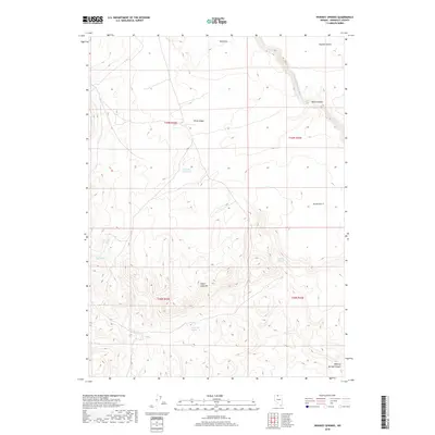
2018 Map of Whiskey Springs
USGS Topo · Published 2018About this map
Whiskey Springs and its surrounding canyon define this corner of Humboldt County, where water sources are the primary landmarks in an arid landscape. This 2018 survey detail shows how vital small water features like Mustang Spring and Little Mud Spring are to the region's geography. The terrain is marked by significant elevation shifts, from the prominent Sugar Loaf Hill and White Ridge to the deep cut of Black Canyon. The N Fork Little Humboldt River flows through the northeast, while man-made infrastructure like the Bull Pen Reservoir indicates modern ranching or land management efforts. The transition into the Owyhee Desert at the northern edge of the map highlights the high-elevation basin character of this section of northern Nevada, where seasonal drainages like Fairbanks Cr carve through the Red Hills.
Find a feature on this map
17 named features on this map. Tap any name to fly to it.
Don’t see what you’re looking for? This feature index may not catch every label — zoom into the map to look around manually.
Map Details
Editions of this 2018 Whiskey Springs Map
This is the sole edition of this map. No revisions or reprints were ever made.
Other maps of this area

1882 · Paradise
USGS Topo · 1:250,000

1893 · Paradise
USGS Topo · 1:250,000

1945 · Hot Springs
USGS Topo · 1:62,500

1947 · Hot Springs Peak
USGS Topo · 1:62,500

1955 · McDermitt
USGS Topo · 1:250,000

1959 · McDermitt
USGS Topo · 1:250,000
1980 · Layton Spring
USGS Topo · 1:24,000
1980 · Button Lake
USGS Topo · 1:24,000

1980 · Greeley Flat
USGS Topo · 1:24,000

1980 · Hardscrabble
USGS Topo · 1:24,000