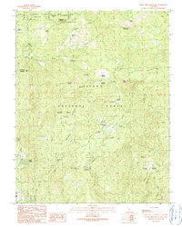
1990 Map of White Chief Mountain
USGS Topo · Published 1990About this map
Yosemite National Park and the Sierra National Forest converge on this 1990 provisional survey, capturing the high-elevation transition between protected wilderness and managed forest lands. The landscape is defined by its seasonal meadows and granite landmarks, including White Chief Mountain and the prominent Fresno Dome. These meadows, such as Soquel Meadow, Goat Meadow, and Boggy Meadow, provided essential water and grazing in an area otherwise dominated by steep timbered slopes. Evidence of land use is visible at the Soquel Meadow Ranch and a Quarry near the Mariposa and Madera county line. The map detail highlights a network of forest camps like Nelder Grove Campground and Texas Flat Group Campground, alongside natural features like Corlieu Falls on Lewis Fork, which illustrate the region's late 20th-century character as a site for both resource management and recreational escape.
Find a feature on this map
46 named features on this map. Tap any name to fly to it.
Don’t see what you’re looking for? This feature index may not catch every label — zoom into the map to look around manually.
Map Details
Editions of this 1990 White Chief Mountain Map
This is the sole edition of this map. No revisions or reprints were ever made.
Other maps of this area

1897 · Yosemite
USGS Topo · 1:125,000

1900 · Yosemite
USGS Topo · 1:125,000

1901 · Mt. Lyell
USGS Topo · 1:125,000

1903 · Yosemite
USGS Topo · 1:125,000

1904 · Kaiser
USGS Topo · 1:125,000

1909 · Yosemite
USGS Topo · 1:125,000

1912 · Mariposa
USGS Topo · 1:125,000

1947 · Mariposa
USGS Topo · 1:250,000

1948 · Mariposa
USGS Topo · 1:250,000

1953 · Merced Peak
USGS Topo · 1:62,500