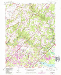
1949 Map of White Marsh
USGS Topo · Published 1987About this map
The Gunpowder Falls State Park corridor anchors this landscape, where the deeply incised waters of Gunpowder Falls and Little Gunpowder Falls define the rugged topography between the Baltimore and Harford county line. The 1949 mapping reveals a transition from the agricultural hamlets of Kingsville and Fork to the growing suburban clusters at Perry Hall and White Marsh. In the southeast, the terrain levels out as Whitemarsh Run and Honeygo Run drain toward the Bird River, while inland, long-established rural centers like Jerusalem, Glen Arm, and Franklinville appear alongside family-named landmarks like Lynchs Corner. Significant local history details include the Baltimore Airpark, the Perry Hall School, and numerous community focal points such as St Stephens Church and Camp Chapel Church. Purple photorevision overlays from the 1980s document the expansion of residential developments and the emergence of the Pulaski Highway as a major commercial artery.
Find a feature on this map
51 named features on this map. Tap any name to fly to it.
Don’t see what you’re looking for? This feature index may not catch every label — zoom into the map to look around manually.
Map Details
Editions of this 1949 White Marsh Map
This is the sole edition of this map. No revisions or reprints were ever made.
Other maps of this area

1893 · Gunpowder
USGS Topo · 1:62,500

1894 · Baltimore
USGS Topo · 1:62,500

1898 · Tolchester
USGS Topo · 1:125,000

1899 · Baltimore
USGS Topo · 1:62,500

1900 · Parkton
USGS Topo · 1:62,500

1901 · Belair
USGS Topo · 1:62,500

1901 · Gunpowder
USGS Topo · 1:62,500

1902 · Parkton
USGS Topo · 1:62,500

1903 · Tolchester
USGS Topo · 1:125,000

1904 · Baltimore
USGS Topo · 1:62,500