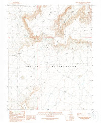
1989 Map of White Mesa Village SE
USGS Topo · Published 1989About this map
The Navajo Indian Reservation landscape is defined by the high, flat expanses of White Mesa and the sheltering contours of White Mesa Valley. This 1989 provisional map, based on fieldwork from the mid-1980s, documents a desert environment where water and infrastructure are central to survival and community life. The Red Mesa Chapter House stands as a primary landmark, while the presence of a Flowing Well, a Water Tank, and multiple Pumping Sta locations highlights the critical importance of groundwater management in this arid territory. The terrain is marked by significant natural drainages like Salt Water Creek and the deep cuts of Creek Canyon, shadowed by Lone Mountain. Industrial markers, such as a long-distance Pipeline and several scattered Drill Hole sites, reflect the ongoing search for resources beneath the mesa floor during the late 20th century.
Find a feature on this map
18 named features on this map. Tap any name to fly to it.
Don’t see what you’re looking for? This feature index may not catch every label — zoom into the map to look around manually.
Map Details
Editions of this 1989 White Mesa Village SE Map
This is the sole edition of this map. No revisions or reprints were ever made.
Other maps of this area

1886 · Abajo
USGS Topo · 1:250,000

1892 · Abajo
USGS Topo · 1:250,000

1892 · Canyon De Chelly
USGS Topo · 1:250,000

1893 · Abajo
USGS Topo · 1:250,000

1953 · Dinne Mesa NW
USGS Topo · 1:24,000

1953 · Pastora Peak NW
USGS Topo · 1:24,000

1953 · Dinne Mesa NE
USGS Topo · 1:24,000

1953 · Pastora Peak
USGS Topo · 1:62,500

1953 · Toh-Atin Mesa
USGS Topo · 1:62,500

1954 · Shiprock
USGS Topo · 1:250,000