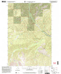
1999 Map of White Mountain
USGS Topo · Published 2003About this map
White Mountain Lookout stands as a prominent high point in this 1990s revision of the Mineral County high country, overlooking the expansive drainage systems of the Lolo National Forest. The landscape is defined by the complex branching of the South Fork Fish Creek, which is fed by numerous named tributaries including Wig Creek, Montana Creek, and Surveyor Creek. Evidence of early settlement or forest management is seen at the Hamilton (Site), located in the eastern portion of the quadrangle near the confluence of several streams. This survey, updated from earlier mid-century data by the USDA Forest Service, provides a meticulous record of the steep terrain between Lion Point and the Third Standard Parallel North, capturing a moment before modern changes significantly altered these western Montana woods.
Find a feature on this map
19 named features on this map. Tap any name to fly to it.
Don’t see what you’re looking for? This feature index may not catch every label — zoom into the map to look around manually.
Map Details
Editions of this 1999 White Mountain Map
This is the sole edition of this map. No revisions or reprints were ever made.
Other maps of this area

1911 · Lolo
USGS Topo · 1:250,000

1913 · Lolo
USGS Topo · 1:250,000

1956 · Hamilton
USGS Topo · 1:250,000

1959 · Hamilton
USGS Topo · 1:250,000

1960 · Hamilton
USGS Topo · 1:250,000

1960 · Straight Peak
USGS Topo · 1:62,500

1964 · Hamilton
USGS Topo · 1:250,000

1964 · Lolo Hot Springs
USGS Topo · 1:24,000
1964 · Williams Peak
USGS Topo · 1:24,000
1964 · Deer Peak
USGS Topo · 1:24,000