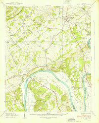
1939 Map of White Pine
USGS Topo · Published 1939About this map
The French Broad River snakes through this 1939 survey, defining the agricultural and social life of eastern Tennessee before significant mid-century changes to the river valley. The landscape is dotted with family-named landmarks and local institutions, such as Anderson Mill and Westminster Cem, which served the dispersed rural population. The town of White Pine serves as the primary hub, connected by the Southern railroad and the Dixie Highway, illustrating the importance of both rail and early highway infrastructure in the region's development.
Find a feature on this map
97 named features on this map. Tap any name to fly to it.
Don’t see what you’re looking for? This feature index may not catch every label — zoom into the map to look around manually.
Map Details
Editions of this 1939 White Pine Map
2 editions found
Other maps of this area

1883 · Morristown
USGS Topo · 1:125,000

1893 · Mt Guyot
USGS Topo · 1:125,000

1893 · Morristown
USGS Topo · 1:125,000

1895 · Morristown
USGS Topo · 1:125,000

1912 · Mt Guyot
USGS Topo · 1:125,000

1935 · Newport
USGS Topo · 1:48,000

1935 · White Pine
USGS Topo · 1:24,000

1935 · English Mountain
USGS Topo · 1:48,000

1935 · Clevenger
USGS Topo · 1:24,000

1935 · Springvale
USGS Topo · 1:24,000