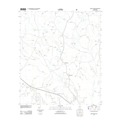
2012 Map of White Plains
USGS Topo · Published 2012About this map
White Plains serves as the focal point of this Harrison County landscape, where the southern Mississippi pine forests are defined by a complex network of waterways. The Tchoutacabouffa River winds through the eastern portion of the area, joined by numerous tributaries including Tuxachanie Cr, Hog Br, and the curiously named Bayou Billie. This 2012 survey illustrates a region of transition, showing the path of Existing Highway 67 and a grid of rural roads like Lamey Bridge Rd and White Plains Rd that connect scattered family homesteads and landmarks. Local history is preserved at sites like Walden Cem near Camp Hill and Krohn Cem to the southeast. The presence of the Leisure Lake Resort Recreational Vehicle Park indicates the area's modern role as a destination for outdoor recreation amidst the dense creek drainages and timberlands.
Find a feature on this map
123 named features on this map. Tap any name to fly to it.
Don’t see what you’re looking for? This feature index may not catch every label — zoom into the map to look around manually.
Map Details
Editions of this 2012 White Plains Map
This is the sole edition of this map. No revisions or reprints were ever made.
Other maps of this area

1953 · Mobile
USGS Topo · 1:250,000

1954 · Vestry
USGS Topo · 1:62,500

1954 · McHenry
USGS Topo · 1:62,500

1954 · Gulfport North
USGS Topo · 1:24,000

1954 · Ocean Springs
USGS Topo · 1:24,000

1954 · Biloxi
USGS Topo · 1:24,000

1954 · Biloxi
USGS Topo · 1:62,500

1957 · Mobile
USGS Topo · 1:250,000

1960 · Mobile
USGS Topo · 1:250,000

1963 · Mobile
USGS Topo · 1:250,000