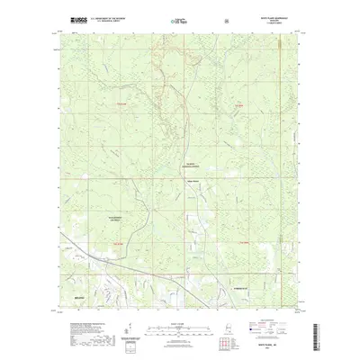
2021 Map of White Plains
USGS Topo · Published 2021About this map
De Soto National Forest dominates the landscape of Harrison County, providing a preserved backdrop for the evolving suburban and rural communities north of the Gulf Coast. The settlement of White Plains sits at a crossroads near the center of the map, while the northwestern reach of Biloxi and D'Iberville extend into the lower sections, showing the northern expansion of these coastal cities. The hydrology is defined by the winding course of the Tchoutacabouffa River and its many tributaries, including Tuxachanie Creek and Hester Creek. This area serves as a significant recreational corridor, evidenced by the extensive Bethel Mountain Bike Trail and Bethel Motorcycle Trail systems. Genealogists will find the locations of Walden Cem near the community of Woolmarket (De Soto) and Krohn Cem to the east, providing specific points of interest for family history research in this forested region.
Find a feature on this map
81 named features on this map. Tap any name to fly to it.
Don’t see what you’re looking for? This feature index may not catch every label — zoom into the map to look around manually.
Map Details
Editions of this 2021 White Plains Map
This is the sole edition of this map. No revisions or reprints were ever made.
Other maps of this area

1953 · Mobile
USGS Topo · 1:250,000

1954 · Vestry
USGS Topo · 1:62,500

1954 · McHenry
USGS Topo · 1:62,500

1954 · Gulfport North
USGS Topo · 1:24,000

1954 · Ocean Springs
USGS Topo · 1:24,000

1954 · Biloxi
USGS Topo · 1:24,000

1954 · Biloxi
USGS Topo · 1:62,500

1957 · Mobile
USGS Topo · 1:250,000

1960 · Mobile
USGS Topo · 1:250,000

1963 · Mobile
USGS Topo · 1:250,000