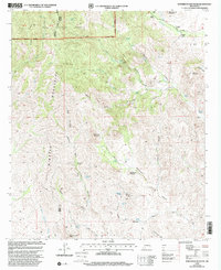
1999 Map of White Rock Mountain
USGS Topo · Published 2002About this map
Mimbres Mountains terrain dominates this late-twentieth-century survey, where the border of Grant and Sierra Counties bisects the high desert landscape. The map reveals a land defined by water scarcity and ranching, evidenced by scattered family-named outposts such as F Latham Ranch, Parks Ranch, and Booth Ranch. Within the Gila National Forest, the topography is carved by an intricate network of drainages including Whiterock Canyon, Pollock Canyon, and Macho Canyon.
Find a feature on this map
48 named features on this map. Tap any name to fly to it.
Don’t see what you’re looking for? This feature index may not catch every label — zoom into the map to look around manually.
Map Details
Editions of this 1999 White Rock Mountain Map
This is the sole edition of this map. No revisions or reprints were ever made.
Other maps of this area

1935 · Hillsboro
USGS Topo · 1:48,000

1940 · Hillsboro
USGS Topo · 1:62,500

1955 · Las Cruces
USGS Topo · 1:250,000

1956 · Dwyer
USGS Topo · 1:62,500

1956 · San Lorenzo
USGS Topo · 1:62,500

1958 · Las Cruces
USGS Topo · 1:250,000

1962 · Lake Valley
USGS Topo · 1:62,500

1982 · Hatch
USGS Topo · 1:100,000
1985 · Dwyer
USGS Topo · 1:24,000
1985 · P A Mountain
USGS Topo · 1:24,000