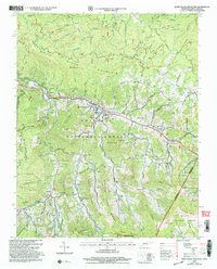
2003 Map of White Rocks Mountain
USGS Topo · Published 2004About this map
The mountain settlement of Roan Mountain and the community of Burbank anchor this high-elevation study along the Tennessee-North Carolina state line. Located within the Cherokee National Forest and Pisgah National Forest, the landscape is defined by the high peaks of White Rocks Mountain, Hump Mountain, and the Yellow Mountain range. The Doe River and its numerous tributaries, such as Buck Creek and Roaring Creek, have carved deep hollows that historically dictated settlement patterns and transport routes.
Find a feature on this map
165 named features on this map. Tap any name to fly to it.
Don’t see what you’re looking for? This feature index may not catch every label — zoom into the map to look around manually.
Map Details
Editions of this 2003 White Rocks Mountain Map
This is the sole edition of this map. No revisions or reprints were ever made.
Other maps of this area

1891 · Roan Mountain
USGS Topo · 1:125,000

1893 · Cranberry
USGS Topo · 1:125,000

1894 · Roan Mountain
USGS Topo · 1:125,000

1895 · Cranberry
USGS Topo · 1:125,000

1899 · Cranberry
USGS Topo · 1:125,000

1902 · Cranberry
USGS Topo · 1:125,000

1904 · Roan Mountain
USGS Topo · 1:125,000

1934 · White Rocks Mtn
USGS Topo · 1:24,000

1934 · Bakersville
USGS Topo · 1:24,000

1934 · Iron Mtn Gap
USGS Topo · 1:24,000