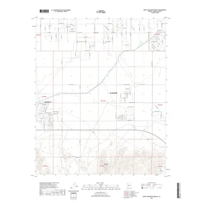
2018 Map of White Tank Mountains NE
USGS Topo · Published 2018About this map
The White Tank Mountains define the southern landscape of this Arizona quadrangle, where the desert terrain transitions into the expanding residential grids of Surprise and Buckeye. This 2018 survey captures a critical period of infrastructure development, most notably the path of the Central Arizona Project Aqueduct as it cuts diagonally across the township. The map illustrates a high-desert environment shaped by ephemeral water systems like Trilby Wash and Iona Wash, alongside man-made features such as Wagner Tank. The north-central and eastern portions are dominated by an emerging network of numbered avenues and named streets like Beardsley Pkwy and Marco Polo Rd, indicating the rapid suburbanization of the Maricopa County desert. In contrast, the southern reaches remain dominated by the steep contours of the mountains, showcasing the intersection of modern municipal growth and the original Sonoran topography.
Find a feature on this map
87 named features on this map. Tap any name to fly to it.
Don’t see what you’re looking for? This feature index may not catch every label — zoom into the map to look around manually.
Map Details
Editions of this 2018 White Tank Mountains NE Map
This is the sole edition of this map. No revisions or reprints were ever made.
Other maps of this area

1954 · Phoenix
USGS Topo · 1:250,000

1957 · Phoenix
USGS Topo · 1:250,000

1957 · White Tank Mts. SE
USGS Topo · 1:24,000

1957 · White Tank Mts. NE
USGS Topo · 1:24,000

1957 · McMicken Dam
USGS Topo · 1:24,000

1957 · Waddell
USGS Topo · 1:24,000

1957 · White Tank Mts.
USGS Topo · 1:62,500

1958 · Phoenix
USGS Topo · 1:250,000

1960 · Phoenix
USGS Topo · 1:250,000
1965 · Wittmann
USGS Topo · 1:24,000