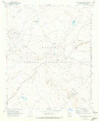
1969 Map of White Water Tank
USGS Topo · Published 1972About this map
The high plateau of the Navajo Indian Reservation in Coconino County is defined by its seasonal water sources and distinct landforms. The Dinnebito Wash carves through the landscape, flanked by the elevated Ward Terrace and Newberry Mesa. This 1969 survey captures a sparsely populated region where human presence is marked by essential infrastructure like the Black Falls Bible Church and a network of livestock tanks, including Little Black Hill Tank, Horse Water Tanks, and White Water Tank. Evidence of indigenous place-naming and heritage is found in features like Lii Haaditiih Hill, Tiis Holoni, and Bidaaii Ta Haali. The map reveals complex land management through the Joint Use Area Bdy, indicating the shared jurisdictional history of the Navajo and Hopi peoples in this arid corridor.
Find a feature on this map
18 named features on this map. Tap any name to fly to it.
Don’t see what you’re looking for? This feature index may not catch every label — zoom into the map to look around manually.
Map Details
Editions of this 1969 White Water Tank Map
This is the sole edition of this map. No revisions or reprints were ever made.
Other maps of this area

1883 · Tusayan
USGS Topo · 1:250,000

1886 · Tusayan
USGS Topo · 1:250,000

1886 · San Francisco Mtns
USGS Topo · 1:250,000

1891 · San Francisco Mtns
USGS Topo · 1:250,000

1894 · San Francisco Mtns
USGS Topo · 1:250,000

1899 · San Francisco Mtns
USGS Topo · 1:250,000

1947 · Flagstaff
USGS Topo · 1:250,000

1954 · Flagstaff
USGS Topo · 1:250,000

1955 · Grand Falls NE
USGS Topo · 1:24,000

1955 · Black Falls 4 SW
USGS Topo · 1:24,000