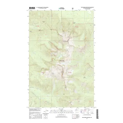
2017 Map of Whitehorse Mountain
USGS Topo · Published 2017About this map
Mount Baker National Forest defines this high-elevation landscape in Snohomish County, where the topography is dominated by the massive profile of Whitehorse Mountain. The survey reveals a complex drainage network feeding into the Boulder River and Squire Creek, with numerous alpine water bodies such as Tucker Lake, Bullon Lake, and Noble Lake situated among the peaks. High-altitude landmarks like Three Fingers and Liberty Mtn mark the horizon, connected by a system of ridges and passes including Lone Tree Pass and Tin Can Gap. This 2017 edition documents the modern boundary lines of the t32n r8e and t31n r9e townships. The absence of developed settlements highlights the wild character of the region, where access is limited to forest service routes like Nat For Dev Rd 4130 and Nat For Dev Rd 4131.
Find a feature on this map
53 named features on this map. Tap any name to fly to it.
Don’t see what you’re looking for? This feature index may not catch every label — zoom into the map to look around manually.
Map Details
Editions of this 2017 Whitehorse Mountain Map
This is the sole edition of this map. No revisions or reprints were ever made.
Other maps of this area

1899 · Stillaguamish
USGS Topo · 1:125,000

1901 · Stilaguamish
USGS Topo · 1:125,000

1955 · Concrete
USGS Topo · 1:250,000

1956 · Oso
USGS Topo · 1:62,500

1956 · Granite Falls
USGS Topo · 1:62,500

1957 · Silverton
USGS Topo · 1:62,500

1958 · Concrete
USGS Topo · 1:250,000

1962 · Concrete
USGS Topo · 1:250,000
1966 · Darrington
USGS Topo · 1:24,000
1966 · Fortson
USGS Topo · 1:24,000