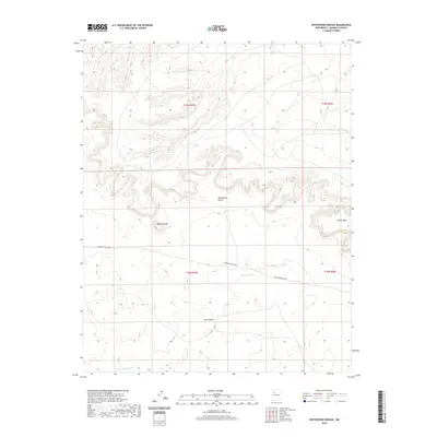
2020 Map of Whitehorse Rincon
USGS Topo · Published 2020About this map
Whitehorse Rincon and the high plateaus of Chaco Mesa dominate this landscape in the Eastern Navajo Agency. The terrain is defined by dramatic geological formations, including the prominent Mesa Cortada and the winding depths of Ojo Canyon. This area reflects the arid high-desert environment of McKinley County, where water management is critical, as evidenced by the presence of Johnson Tank and the seasonal drainage of the N Fork Arroyo Chico. Sparse infrastructure connects the region, primarily through Navajo Svc Rte 7004 and Rincon Marquez Rd, which trace the base of the mesas. The map provides a clear look at the Public Land Survey System grid across T19N and T18N, illustrating how these administrative boundaries overlay the complex topography of New Mexico’s canyon country.
Find a feature on this map
12 named features on this map. Tap any name to fly to it.
Don’t see what you’re looking for? This feature index may not catch every label — zoom into the map to look around manually.
Map Details
Editions of this 2020 Whitehorse Rincon Map
This is the sole edition of this map. No revisions or reprints were ever made.
Other maps of this area

1883 · Mt. Taylor
USGS Topo · 1:250,000

1886 · Mt. Taylor
USGS Topo · 1:250,000

1892 · Mt. Taylor
USGS Topo · 1:250,000

1899 · Mt. Taylor
USGS Topo · 1:250,000

1958 · Albuquerque
USGS Topo · 1:250,000

1960 · Pueblo Alto Trading Post
USGS Topo · 1:24,000
1961 · Star Lake
USGS Topo · 1:24,000

1961 · Whitehorse Rincon
USGS Topo · 1:24,000

1961 · Whitehorse
USGS Topo · 1:24,000

1961 · Mesita Del Gavilan
USGS Topo · 1:24,000