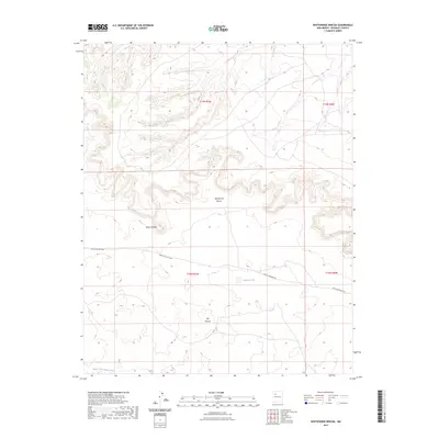
2023 Map of Whitehorse Rincon
USGS Topo · Published 2023About this map
Whitehorse Rincon occupies a high-desert landscape in McKinley County, defined by the striking topography of Mesa Cortada and the winding course of Ojo Canyon. This modern survey by the U.S. Geological Survey captures the intricate network of service roads and traditional routes that traverse the region, including Navajo Svc Rte 7004 and the Rincon Marquez Rd. The map illustrates a remote environment where water management is critical, as evidenced by the presence of Johnson Tank and the seasonal drainage of the North Fork Arroyo Chico. The spatial arrangement of these landmarks reflects the enduring land use patterns in this part of New Mexico, showing how geography and infrastructure intersect in a sparsely populated terrain.
Find a feature on this map
11 named features on this map. Tap any name to fly to it.
Don’t see what you’re looking for? This feature index may not catch every label — zoom into the map to look around manually.
Map Details
Editions of this 2023 Whitehorse Rincon Map
This is the sole edition of this map. No revisions or reprints were ever made.
Other maps of this area

1883 · Mt. Taylor
USGS Topo · 1:250,000

1886 · Mt. Taylor
USGS Topo · 1:250,000

1892 · Mt. Taylor
USGS Topo · 1:250,000

1899 · Mt. Taylor
USGS Topo · 1:250,000

1958 · Albuquerque
USGS Topo · 1:250,000

1960 · Pueblo Alto Trading Post
USGS Topo · 1:24,000
1961 · Star Lake
USGS Topo · 1:24,000

1961 · Whitehorse Rincon
USGS Topo · 1:24,000

1961 · Whitehorse
USGS Topo · 1:24,000

1961 · Mesita Del Gavilan
USGS Topo · 1:24,000