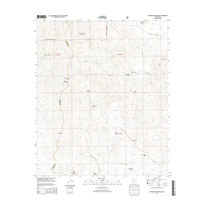
2013 Map of Whiterock Mountain
USGS Topo · Published 2013About this map
Whiterock Mtn and the surrounding high country of the Gila National Forest define this landscape along the boundary of Grant and Sierra Counties. The terrain is deeply incised by a network of drainage systems, including Whiterock Canyon, Bear Springs Canyon, and Taylor Canyon, which flow through the southern Mimbrés Mountains. This environment is punctuated by vital water sources like Log Spring and Mule Springs Cr, which would have been critical points for early livestock ranching and travel through the high desert. The presence of routes such as Co Road B002 and Co Road B001 suggests a history of access to these remote canyons. Researchers can find numerous named peaks and draws, such as Log Springs Mtn and Ricketson Draw, reflecting the local nomenclature of the region.
Find a feature on this map
45 named features on this map. Tap any name to fly to it.
Don’t see what you’re looking for? This feature index may not catch every label — zoom into the map to look around manually.
Map Details
Editions of this 2013 Whiterock Mountain Map
This is the sole edition of this map. No revisions or reprints were ever made.
Other maps of this area

1935 · Hillsboro
USGS Topo · 1:48,000

1940 · Hillsboro
USGS Topo · 1:62,500

1955 · Las Cruces
USGS Topo · 1:250,000

1956 · Dwyer
USGS Topo · 1:62,500

1956 · San Lorenzo
USGS Topo · 1:62,500

1958 · Las Cruces
USGS Topo · 1:250,000

1962 · Lake Valley
USGS Topo · 1:62,500

1982 · Hatch
USGS Topo · 1:100,000
1985 · Dwyer
USGS Topo · 1:24,000
1985 · P A Mountain
USGS Topo · 1:24,000