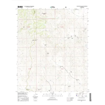
2017 Map of Whiterock Mountain
USGS Topo · Published 2017About this map
The Mimbres Mountains form a high-altitude spine across this section of the Gila National Forest, where the boundary between Grant and Sierra counties meets. This landscape is defined by its complex drainage network, carved by centuries of seasonal water movement through landmarks like Whiterock Canyon and Bear Springs Canyon. The prominence of Whiterock Mountain serves as a central anchor, surrounded by numerous named water sources that were essential for early ranching and transit, including Log Spring, Taylor Spring, and Grapevine Spring. Modern access is represented by routes like Co RD b002, which winds through the deep topography of Taylor Canyon. The map reveals a transition from the higher peaks of Schoolhouse Mtn down toward the southern drainage systems of Dove Springs Canyon, illustrating the isolated and resource-dependent nature of this Southwestern backcountry.
Find a feature on this map
44 named features on this map. Tap any name to fly to it.
Don’t see what you’re looking for? This feature index may not catch every label — zoom into the map to look around manually.
Map Details
Editions of this 2017 Whiterock Mountain Map
This is the sole edition of this map. No revisions or reprints were ever made.
Other maps of this area

1935 · Hillsboro
USGS Topo · 1:48,000

1940 · Hillsboro
USGS Topo · 1:62,500

1955 · Las Cruces
USGS Topo · 1:250,000

1956 · Dwyer
USGS Topo · 1:62,500

1956 · San Lorenzo
USGS Topo · 1:62,500

1958 · Las Cruces
USGS Topo · 1:250,000

1962 · Lake Valley
USGS Topo · 1:62,500

1982 · Hatch
USGS Topo · 1:100,000
1985 · Dwyer
USGS Topo · 1:24,000
1985 · P A Mountain
USGS Topo · 1:24,000