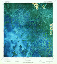
1972 Map of Whitewater Bay East
USGS Topo · Published 1975About this map
Everglades National Park appears in this orthophotomap as a complex network of coastal mangrove forests and brackish waterways. The 1971 aerial photography captured the intricate delta-like systems of the Watson River, North River, and Lane River as they drain into the shallow expanse of Whitewater Bay. The landscape is dominated by tidal channels and numerous small islands or Keys, where land and water are indistinguishable without the precision of this infrared-tinted survey. Hydrographic data highlights navigable routes like the Midway Waterway and Midway Pass, essential for traversing this portion of the Florida coast. Remote Campsite locations are marked within the Wilderness designation, indicating the area's preservation for primitive recreation. Notable for its lack of terrestrial infrastructure, the map illustrates the natural hydrology of Hells Bay and Norths Bay before modern environmental shifts altered these sensitive coastal zones.
Find a feature on this map
14 named features on this map. Tap any name to fly to it.
Don’t see what you’re looking for? This feature index may not catch every label — zoom into the map to look around manually.
Map Details
Editions of this 1972 Whitewater Bay East Map
2 editions found
Other maps of this area

1956 · Miami
USGS Topo · 1:250,000

1958 · Miami
USGS Topo · 1:250,000

1972 · Whitewater Bay West
USGS Topo · 1:24,000

1972 · Whitewater Bay East
USGS Topo · 1:24,000

1972 · Mahogany Hammock
USGS Topo · 1:24,000

1972 · Harney River
USGS Topo · 1:24,000

1972 · Lake Ingraham East
USGS Topo · 1:24,000

1972 · West Lake
USGS Topo · 1:24,000

1972 · Tarpon Bay
USGS Topo · 1:24,000

1972 · Pa Hay Okee Lookout Tower
USGS Topo · 1:24,000