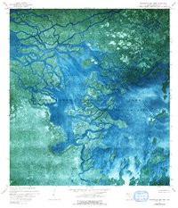
1972 Map of Whitewater Bay West
USGS Topo · Published 1990About this map
Everglades National Park appears here as a labyrinthine network of mangroves and tidewater channels captured in 1971 through aerial photography. The map reveals the intricate hydrologic connection between the Shark River and Whitewater Bay, emphasizing the complex estuarine environment where saltwater and freshwater mix. Large bodies of water like Oyster Bay and Ponce De Leon Bay are separated by fragmented landmasses such as Shark River Island, while the Wilderness Waterway provides a clear transit route through the coastal vegetation. The absence of roads or cultural structures, save for occasional primitive Campsite markers, underscores the preserved state of the Cape Sable region during this period of ecological mapping.
Find a feature on this map
14 named features on this map. Tap any name to fly to it.
Don’t see what you’re looking for? This feature index may not catch every label — zoom into the map to look around manually.
Map Details
Editions of this 1972 Whitewater Bay West Map
2 editions found
Other maps of this area

1956 · Miami
USGS Topo · 1:250,000

1958 · Miami
USGS Topo · 1:250,000

1972 · Whitewater Bay West
USGS Topo · 1:24,000

1972 · Whitewater Bay East
USGS Topo · 1:24,000

1972 · Harney River
USGS Topo · 1:24,000

1972 · Lake Ingraham East
USGS Topo · 1:24,000
1972 · Lake Ingraham West
USGS Topo · 1:24,000

1972 · Tarpon Bay
USGS Topo · 1:24,000

1972 · Shark River Island
USGS Topo · 1:24,000

1972 · Shark Point
USGS Topo · 1:24,000