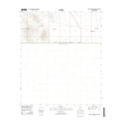
2013 Map of Whitewater Mountains
USGS Topo · Published 2013About this map
Antelope Wells sits at the southern terminus of NM-81, marking a critical point along the international boundary between the United States and Mexico. This high-desert landscape in Hidalgo County is dominated by the Whitewater Mountains and the strategic San Luis Pass, which provides passage through the prominent terrain. Water management is central to this arid environment, as evidenced by naming conventions like Boogs Defeat Tank and Highway Tank, alongside the seasonal course of Deer Cr. The map illustrates the sparse settlement patterns and significant infrastructure at the border, where the Playas Valley opens toward the horizon. Researchers will find a clear depiction of the Public Land Survey System grids, including t34s r17w and its neighbors, which organize this remote corner of New Mexico.
Find a feature on this map
15 named features on this map. Tap any name to fly to it.
Don’t see what you’re looking for? This feature index may not catch every label — zoom into the map to look around manually.
Map Details
Editions of this 2013 Whitewater Mountains Map
This is the sole edition of this map. No revisions or reprints were ever made.
Other maps of this area

1917 · Antelope Wells
USGS Topo · 1:62,500

1918 · Dog Mountains
USGS Topo · 1:62,500

1919 · Antelope Wells
USGS Topo · 1:62,500

1955 · Douglas
USGS Topo · 1:250,000

1959 · Douglas
USGS Topo · 1:250,000

1961 · Douglas
USGS Topo · 1:250,000

1964 · Douglas
USGS Topo · 1:250,000
1982 · Hilo Peak
USGS Topo · 1:24,000
1982 · San Luis Pass
USGS Topo · 1:24,000
1982 · Sentinel Butte
USGS Topo · 1:24,000