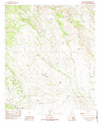
1982 Map of San Luis Pass
USGS Topo · Published 1982About this map
The Continental Divide winds through this high-altitude corner of Hidalgo County, marking the spine between the Animas Mountains and the San Luis Mountains. The landscape is defined by its drainage systems and water catchment, featuring a network of named stock tanks such as Big Geronimo Tank, Smith Tank, and Pendleton Tank that supported ranching operations in this arid environment. Movement through the passes and along the foothills is traced by a network of jeep trails and unimproved roads, following natural corridors like Lynch Draw and Aiken Draw. The map captures a moment in the early 1980s when this remote borderland region remained sparsely developed, dominated by the natural features of the Smuggler Hills and the strategically significant San Luis Pass. It reflects a late-century land-use pattern where topographic elevation and seasonal water sources dictated the placement of every landmark and trail.
Find a feature on this map
43 named features on this map. Tap any name to fly to it.
Don’t see what you’re looking for? This feature index may not catch every label — zoom into the map to look around manually.
Map Details
Editions of this 1982 San Luis Pass Map
This is the sole edition of this map. No revisions or reprints were ever made.
Other maps of this area

1917 · Antelope Wells
USGS Topo · 1:62,500

1918 · Walnut Wells
USGS Topo · 1:62,500

1918 · Cienega Springs
USGS Topo · 1:62,500

1918 · Animas Peak
USGS Topo · 1:62,500

1919 · Antelope Wells
USGS Topo · 1:62,500

1920 · Animas Peak
USGS Topo · 1:62,500

1923 · Walnut Wells
USGS Topo · 1:62,500

1955 · Douglas
USGS Topo · 1:250,000

1959 · Douglas
USGS Topo · 1:250,000

1961 · Douglas
USGS Topo · 1:250,000