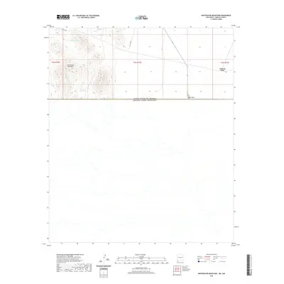
2020 Map of Whitewater Mountains
USGS Topo · Published 2020About this map
The United States of America Estados Unidos Mexicanos border cuts directly across this landscape, marking a stark geopolitical division in the high desert. To the north, the rugged terrain of the Whitewater Mountains rises sharply, providing a dramatic backdrop to the remote international crossing at Antelope Wells. This area serves as a critical point of transit and monitoring along the southern edge of Hidalgo County, where the desert floor of the Playas Valley meets the mountain passes. Sparse water sources are noted by labels such as Highway Tank and the uniquely named Boogs Defeat Tank, reflecting the arid conditions that shaped ranching and travel through the San Luis Pass. The map details the transition from the mountainous township of t34s r18w into the open drainage of Deer Cr and the valley to the east.
Find a feature on this map
11 named features on this map. Tap any name to fly to it.
Don’t see what you’re looking for? This feature index may not catch every label — zoom into the map to look around manually.
Map Details
Editions of this 2020 Whitewater Mountains Map
This is the sole edition of this map. No revisions or reprints were ever made.
Other maps of this area

1917 · Antelope Wells
USGS Topo · 1:62,500

1918 · Dog Mountains
USGS Topo · 1:62,500

1919 · Antelope Wells
USGS Topo · 1:62,500

1955 · Douglas
USGS Topo · 1:250,000

1959 · Douglas
USGS Topo · 1:250,000

1961 · Douglas
USGS Topo · 1:250,000

1964 · Douglas
USGS Topo · 1:250,000
1982 · Hilo Peak
USGS Topo · 1:24,000
1982 · San Luis Pass
USGS Topo · 1:24,000
1982 · Sentinel Butte
USGS Topo · 1:24,000