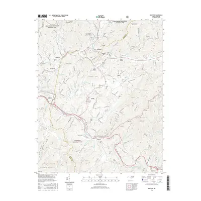
2016 Map of Whittier
USGS Topo · Published 2016About this map
Oconaluftee Indian Village and the town of Cherokee anchor this 2016 survey of the Qualla Boundary, where the Oconaluftee River meets Soco Cr. This landscape is a densely named network of family and community heritage, evidenced by the numerous cemeteries scattered across the slopes, including Birdtown Cem, Sneed Cem, and Stamper Cem. The topography is defined by significant ridges and coves, such as Spray Ridge and Hoot Owl Cove, while the southern reaches follow the Tuckasegee River through Whittier toward Dillsboro. This modern topographic record reveals the persistence of traditional settlements like Birdtown and Qualla alongside modern landmarks like Homer Burgess Lake. The border between Swain Co and Jackson Co bisects the terrain, illustrating how political boundaries overlay the natural drainage basins of Wrights Cr and Nations Cr.
Find a feature on this map
176 named features on this map. Tap any name to fly to it.
Don’t see what you’re looking for? This feature index may not catch every label — zoom into the map to look around manually.
Map Details
Editions of this 2016 Whittier Map
This is the sole edition of this map. No revisions or reprints were ever made.
Other maps of this area

1891 · Cowee
USGS Topo · 1:125,000

1893 · Mt Guyot
USGS Topo · 1:125,000

1897 · Cowee
USGS Topo · 1:125,000

1907 · Cowee
USGS Topo · 1:125,000

1912 · Mt Guyot
USGS Topo · 1:125,000

1933 · Bryson
USGS Topo · 1:62,500

1935 · Cullowhee
USGS Topo · 1:24,000

1935 · Addie
USGS Topo · 1:24,000
1936 · Greens Creek
USGS Topo · 1:24,000

1936 · Bunches Bald
USGS Topo · 1:24,000
Featured Places
- Cherokee, Yellowhill Community
- Birdtown Community, NC
- Indian Hills, NC
- Wilmot, NC
- Birdtown, Birdtown Community