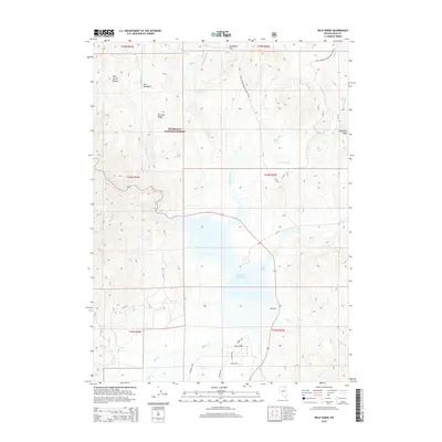
2015 Map of Wild Horse
USGS Topo · Published 2015About this map
Wild Horse Reservoir dominates the high desert landscape of this Elko County region, serving as a central catchment for the Owyhee River and its numerous mountain tributaries. The surrounding area within the Humboldt National Forest is defined by sharp elevation changes, from the prominent Poorman Peak in the northeast to the Wild Horse Range in the northwest. This 2015 survey reveals a complex network of seasonal drainages such as Hendricks Cr and Warm Cr feeding into the basin. To the south of the reservoir, a modern street grid appears with names like Jasper Ave and Emerald Ave, contrasting with the more traditional land features like Sunflower Flat and Lost Meadows. Notable water sources, including Poorman Spring and Hot Springs, indicate the geothermal and hydrologic character of this high-elevation terrain.
Find a feature on this map
38 named features on this map. Tap any name to fly to it.
Don’t see what you’re looking for? This feature index may not catch every label — zoom into the map to look around manually.
Map Details
Editions of this 2015 Wild Horse Map
This is the sole edition of this map. No revisions or reprints were ever made.
Other maps of this area

1935 · Charleston
USGS Topo · 1:48,000

1936 · Mountain City
USGS Topo · 1:62,500

1936 · Rowland
USGS Topo · 1:48,000

1940 · Rowland
USGS Topo · 1:62,500

1940 · Mountain City
USGS Topo · 1:62,500

1942 · Mt. Velma
USGS Topo · 1:62,500

1955 · Wells
USGS Topo · 1:250,000

1956 · Wild Horse
USGS Topo · 1:62,500

1958 · Wells
USGS Topo · 1:250,000

1961 · Wells
USGS Topo · 1:250,000