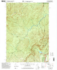
1995 Map of Wild River
USGS Topo · Published 2000About this map
The Wild River cuts through this high-elevation region of the White Mountain National Forest along the border of New Hampshire and Maine. In this mid-1990s survey, the landscape is defined by its recreation and conservation infrastructure, featuring a dense network of backcountry paths including the Appalachian Trail and the Rattle River Scenic Trail. Cultural landmarks like the Brickett Place and various wilderness stations, such as the Spruce Brook Shelter and Blue Brook Shelter, provide reference points for those tracking historic land use in the White Mountains. Steep topography is anchored by prominent peaks like Shelburne Moriah Mountain and West Royce Mountain, while water features like Basin Pond and the Moriah Gorge illustrate the drainage patterns that shaped the early logging and travel routes of Beans Purchase and Shelburne.
Find a feature on this map
57 named features on this map. Tap any name to fly to it.
Don’t see what you’re looking for? This feature index may not catch every label — zoom into the map to look around manually.
Map Details
Editions of this 1995 Wild River Map
This is the sole edition of this map. No revisions or reprints were ever made.
Other maps of this area

1893 · Gorham
USGS Topo · 1:62,500

1894 · North Conway
USGS Topo · 1:62,500

1896 · North Conway
USGS Topo · 1:62,500

1896 · Gorham
USGS Topo · 1:62,500

1909 · Fryeburg
USGS Topo · 1:62,500

1911 · Fryeburg
USGS Topo · 1:62,500

1914 · Bethel
USGS Topo · 1:62,500

1937 · Gorham
USGS Topo · 1:48,000

1940 · Bethel
USGS Topo · 1:62,500

1941 · Bethel
USGS Topo · 1:62,500