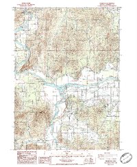
1986 Map of Wilderville
USGS Topo · Published 1986About this map
The Rogue River dominates this mid-1980s landscape, serving as a focal point for recreation and local transport at the confluence with the Applegate River. This area showcases the transition from the river-bottom agriculture of Jerome Prairie to the steeper elevations of Sloan Mountain. A legacy of earlier transportation is visible in the Old Railroad Grade tracing through the valley, while more contemporary infrastructure like the Robertson Bridge and several river access points like Lathrop Boat Landing emphasize the importance of the water for the community. The small settlement of Wilderville anchors the southwestern portion of the sheet near Cheney Creek, while the presence of a Cemetery and a local Community College reflect the established social fabric of this rural Oregon region during the late twentieth century.
Find a feature on this map
37 named features on this map. Tap any name to fly to it.
Don’t see what you’re looking for? This feature index may not catch every label — zoom into the map to look around manually.
Map Details
Editions of this 1986 Wilderville Map
This is the sole edition of this map. No revisions or reprints were ever made.
Other maps of this area

1904 · Riddle
USGS Topo · 1:125,000

1908 · Grants Pass
USGS Topo · 1:125,000

1917 · Kerby
USGS Topo · 1:125,000

1918 · Kerby
USGS Topo · 1:125,000

1945 · Kerby
USGS Topo · 1:125,000

1946 · Galice
USGS Topo · 1:62,500

1948 · Galice
USGS Topo · 1:62,500

1954 · Glendale
USGS Topo · 1:62,500

1954 · Selma
USGS Topo · 1:62,500

1954 · Grants Pass
USGS Topo · 1:62,500