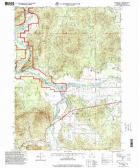
1996 Map of Wilderville
USGS Topo · Published 1999About this map
Wilderville serves as a focal point in this Josephine County landscape, where the confluence of the Applegate River and the Rogue River dictates the local geography. The map reveals an area defined by agricultural and recreational development, featuring the expansive Jerome Prairie and water management systems like the Main Canal and South Canal. Notable landmarks such as the Outdoor Theater and a local Community College reflect the community's growth in the late twentieth century. Along the riverbanks, numerous access points including Robertson Bridge and Griffin Park underscore the region's relationship with its waterways, while the rugged elevation of Sloan Mountain rises to the southwest. Detailed infrastructure like the Substation and Sewage Disposal facility are noted alongside local history markers such as the Cemetery near the river bend.
Find a feature on this map
44 named features on this map. Tap any name to fly to it.
Don’t see what you’re looking for? This feature index may not catch every label — zoom into the map to look around manually.
Map Details
Editions of this 1996 Wilderville Map
This is the sole edition of this map. No revisions or reprints were ever made.
Other maps of this area

1904 · Riddle
USGS Topo · 1:125,000

1908 · Grants Pass
USGS Topo · 1:125,000

1917 · Kerby
USGS Topo · 1:125,000

1918 · Kerby
USGS Topo · 1:125,000

1945 · Kerby
USGS Topo · 1:125,000

1946 · Galice
USGS Topo · 1:62,500

1948 · Galice
USGS Topo · 1:62,500

1954 · Glendale
USGS Topo · 1:62,500

1954 · Selma
USGS Topo · 1:62,500

1954 · Grants Pass
USGS Topo · 1:62,500