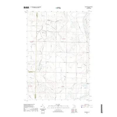
2019 Map of Wildwood
USGS Topo · Published 2019About this map
Wildwood and Rondo anchor this northern Michigan landscape at the intersection of Emmet, Cheboygan, and Charlevoix counties. The map reveals a region defined by its water and woods, where the Sturgeon River and W Br Sturgeon River flow through the eastern corridor. Recreational and historic routes are prominent, including the N Central State Trail and extensive systems like the Wildwood Hills Pathway and Lost Tamarack Pathway that wind through the upland terrain and the Berry Creek Valley. Local genealogy is preserved at the Rondo Cem and Silver Lake Cem, situated near small kettle lakes such as Weber Lake, Silver Lake, and Barhite Lake. The grid of secondary roads, like Wildwood RD and Sturgeon Valley DR, provides a detailed look at the rural settlement patterns and forest access points established by the late 2010s.
Find a feature on this map
77 named features on this map. Tap any name to fly to it.
Don’t see what you’re looking for? This feature index may not catch every label — zoom into the map to look around manually.
Map Details
Editions of this 2019 Wildwood Map
This is the sole edition of this map. No revisions or reprints were ever made.
Other maps of this area

1954 · Gaylord
USGS Topo · 1:62,500

1955 · Cheboygan
USGS Topo · 1:250,000

1957 · Wolverine
USGS Topo · 1:62,500

1958 · Cheboygan
USGS Topo · 1:250,000

1958 · Petoskey
USGS Topo · 1:62,500

1961 · Boyne Falls
USGS Topo · 1:62,500

1975 · Petoskey NE
USGS Topo · 1:24,000

1982 · Petoskey
USGS Topo · 1:100,000
1983 · Alanson
USGS Topo · 1:24,000
1983 · Epsilon
USGS Topo · 1:25,000