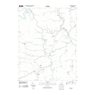
2010 Map of Willard
USGS Topo · Published 2010About this map
Willard stands at the center of this rural Kentucky landscape, where the Little Fork Little Sandy River carves through a network of hollows and ridges. The map reveals a community structured around family heritage and small settlements like Beetle, Antioch, and Johns Run. Genealogists will find a high density of burial grounds, including the Hall Cemetery, Kitchen Cemetery, and Boggs Cemetery, often tucked away near family homesteads and church sites like the Mountain Chapel United Baptist Church.
Find a feature on this map
98 named features on this map. Tap any name to fly to it.
Don’t see what you’re looking for? This feature index may not catch every label — zoom into the map to look around manually.
Map Details
Editions of this 2010 Willard Map
This is the sole edition of this map. No revisions or reprints were ever made.
Other maps of this area

1903 · Kenova
USGS Topo · 1:125,000

1904 · Kenova
USGS Topo · 1:125,000

1950 · Bruin
USGS Topo · 1:24,000

1950 · Grahn
USGS Topo · 1:24,000

1950 · Isonville
USGS Topo · 1:24,000

1953 · Grayson
USGS Topo · 1:24,000

1953 · Rush
USGS Topo · 1:24,000
1953 · Mazie
USGS Topo · 1:24,000
1953 · Webbville
USGS Topo · 1:24,000
1953 · Willard
USGS Topo · 1:24,000