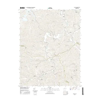
2016 Map of Willard
USGS Topo · Published 2016About this map
The Little Fork Little Sandy River winds through this Eastern Kentucky landscape, defining the topography of the region near the border of Carter, Lawrence, and Elliott counties. Small residential clusters and family settlements such as Beetle, Dobbins, and Stephens are connected by a network of winding roads like Rosedale Rd and Blaine Trace Rd. The area is characterized by significant genealogical landmarks, including family-named burial sites such as Kitchen Cem, McDavid Cem, and the Womack Graveyard. In the northwest corner, the waters of Grayson Lake reach into the creek valleys, while distinctive landforms like Backbone Hill and Shingle Gap rise above the many branching waterways. The prevalence of branch and hollow names, from Silver Mines Br to Marshall Hollow, reflects a long history of local land naming conventions tied to the narrow valleys and ridges of the Cumberland Plateau.
Find a feature on this map
114 named features on this map. Tap any name to fly to it.
Don’t see what you’re looking for? This feature index may not catch every label — zoom into the map to look around manually.
Map Details
Editions of this 2016 Willard Map
This is the sole edition of this map. No revisions or reprints were ever made.
Other maps of this area

1903 · Kenova
USGS Topo · 1:125,000

1904 · Kenova
USGS Topo · 1:125,000

1950 · Bruin
USGS Topo · 1:24,000

1950 · Grahn
USGS Topo · 1:24,000

1950 · Isonville
USGS Topo · 1:24,000

1953 · Grayson
USGS Topo · 1:24,000

1953 · Rush
USGS Topo · 1:24,000
1953 · Mazie
USGS Topo · 1:24,000
1953 · Webbville
USGS Topo · 1:24,000
1953 · Willard
USGS Topo · 1:24,000