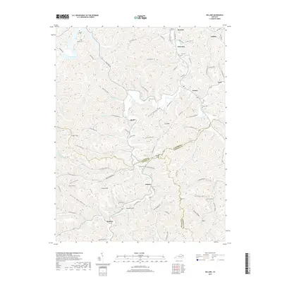
2019 Map of Willard
USGS Topo · Published 2019About this map
Little Fork Little Sandy River carves through a deeply dissected landscape where the boundaries of Carter, Elliott, and Lawrence Counties converge. This rural section of eastern Kentucky is defined by narrow hollows and steep ridges such as Greasy Ridge and Dry Ridge, where small communities like Dobbins, Beetle, and Willard are connected by a network of winding roads following the creek beds. The map reveal a highly localized settlement pattern, with family names preserved in features like McDavid Cem, Womack Graveyard, and Hensley Hollow.
Find a feature on this map
113 named features on this map. Tap any name to fly to it.
Don’t see what you’re looking for? This feature index may not catch every label — zoom into the map to look around manually.
Map Details
Editions of this 2019 Willard Map
This is the sole edition of this map. No revisions or reprints were ever made.
Other maps of this area

1903 · Kenova
USGS Topo · 1:125,000

1904 · Kenova
USGS Topo · 1:125,000

1950 · Bruin
USGS Topo · 1:24,000

1950 · Grahn
USGS Topo · 1:24,000

1950 · Isonville
USGS Topo · 1:24,000

1953 · Grayson
USGS Topo · 1:24,000

1953 · Rush
USGS Topo · 1:24,000
1953 · Mazie
USGS Topo · 1:24,000
1953 · Webbville
USGS Topo · 1:24,000
1953 · Willard
USGS Topo · 1:24,000