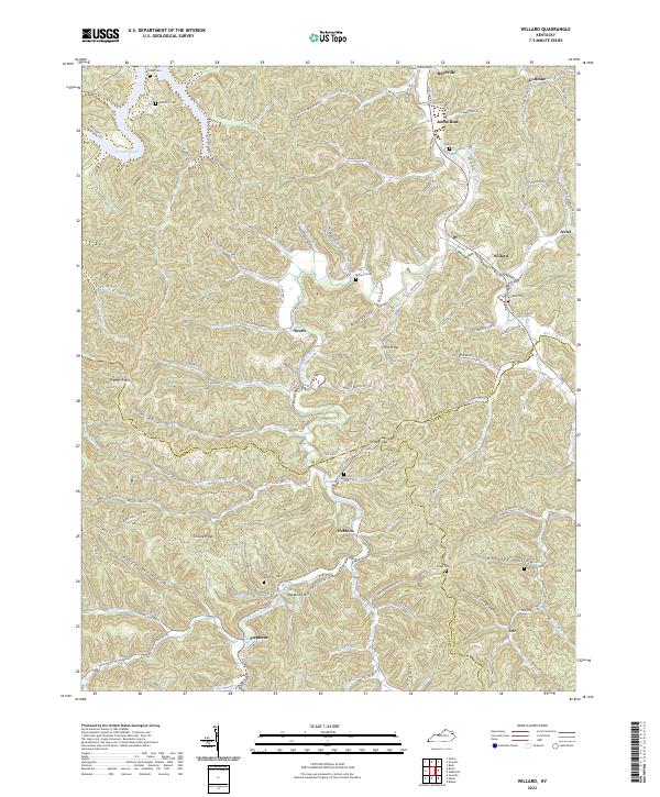
2022 Map of Willard
USGS Topo · Published 2022About this map
Willard sits at the convergence of rugged creek valleys where Little Fork Little Sandy River meets Lost Cr, serving as a central hub for the surrounding Appalachian hollows. The settlement pattern here follows the narrow drainages, with clusters of family cemeteries such as Sammons Cem and McDavid Cem marking the legacy of long-standing rural communities. To the northwest, the map shows the upper reaches of Grayson Lake, a significant water feature that transforms the local geography. The complex topography is defined by prominent landmarks like Backbone Hill and deep recesses such as Black Hollow and Hensley Hollow. Throughout this territory, small hamlets like Beetle and Johns Run remain connected by winding routes like State Hwy 1496, illustrating the enduring layout of eastern Kentucky's upland settlements.
Find a feature on this map
110 named features on this map. Tap any name to fly to it.
Don’t see what you’re looking for? This feature index may not catch every label — zoom into the map to look around manually.
Map Details
Editions of this 2022 Willard Map
This is the sole edition of this map. No revisions or reprints were ever made.
Other maps of this area

1903 · Kenova
USGS Topo · 1:125,000

1904 · Kenova
USGS Topo · 1:125,000

1950 · Bruin
USGS Topo · 1:24,000

1950 · Grahn
USGS Topo · 1:24,000

1950 · Isonville
USGS Topo · 1:24,000

1953 · Grayson
USGS Topo · 1:24,000

1953 · Rush
USGS Topo · 1:24,000
1953 · Mazie
USGS Topo · 1:24,000
1953 · Webbville
USGS Topo · 1:24,000
1953 · Willard
USGS Topo · 1:24,000