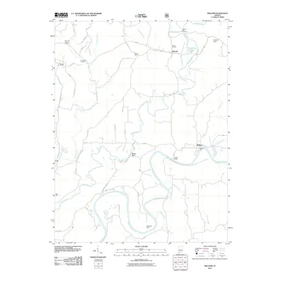
2010 Map of Williams
USGS Topo · Published 2010About this map
The East Fork White River carves a deep, winding path through this portion of Lawrence County, anchoring the settlements of Williams and Mount Olive. In the early 21st century, the landscape remains defined by its water systems and the river’s infrastructure, notably the Williams Dam and the nearby Williams Bridge. This area is particularly rich in genealogical data, preserving the locations of numerous family and community burial grounds such as Mountain Spring Cemetery, Uno-Paton Cemetery, and Pleasant Hill Cemetery. Away from the main river valley, the terrain is segmented by numerous tributaries including Indian Creek and Sulphur Creek, while smaller communities like Silverville and Cale serve as local landmarks. The documentation of Henshaw Bond and LaSalle Springs provides further evidence of the rural settlement patterns and natural features that have persisted in this part of Indiana.
Find a feature on this map
47 named features on this map. Tap any name to fly to it.
Don’t see what you’re looking for? This feature index may not catch every label — zoom into the map to look around manually.
Map Details
Editions of this 2010 Williams Map
This is the sole edition of this map. No revisions or reprints were ever made.
Other maps of this area

1935 · Oolitic
USGS Topo · 1:48,000

1942 · Oolitic
USGS Topo · 1:62,500

1948 · Huron
USGS Topo · 1:24,000

1949 · Georgia
USGS Topo · 1:24,000

1950 · Huron
USGS Topo · 1:24,000

1950 · Shoals
USGS Topo · 1:24,000

1951 · Georgia
USGS Topo · 1:24,000

1956 · Koleen
USGS Topo · 1:24,000

1956 · Indian Springs
USGS Topo · 1:24,000

1956 · Vincennes
USGS Topo · 1:250,000