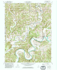
1978 Map of Williams
USGS Topo · Published 1979About this map
The East Fork White River winds through the heart of this Southern Indiana landscape, creating dramatic oxbows like Henshaw Bend and natural river features such as Chase Ripple. Much of the northern portion of the terrain is defined by the U S Naval Reservation Weapons Support Center, which borders the extensive wooded reaches of the Hoosier National Forest. The map provides a detailed view of local infrastructure in the late 1970s, from the industrial presence of scattered Quarries to the path of the Chicago Milwaukee St Paul and Pacific railroad.
Find a feature on this map
37 named features on this map. Tap any name to fly to it.
Don’t see what you’re looking for? This feature index may not catch every label — zoom into the map to look around manually.
Map Details
Editions of this 1978 Williams Map
2 editions found
Other maps of this area

1935 · Oolitic
USGS Topo · 1:48,000

1942 · Oolitic
USGS Topo · 1:62,500

1948 · Huron
USGS Topo · 1:24,000

1949 · Georgia
USGS Topo · 1:24,000

1950 · Huron
USGS Topo · 1:24,000

1950 · Shoals
USGS Topo · 1:24,000

1951 · Georgia
USGS Topo · 1:24,000

1956 · Koleen
USGS Topo · 1:24,000

1956 · Indian Springs
USGS Topo · 1:24,000

1956 · Vincennes
USGS Topo · 1:250,000