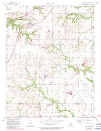
1956 Map of Williamsburg
USGS Topo · Published 1983About this map
The town of Williamsburg serves as a focal point in this mid-century topographic study of Franklin County, showing a landscape defined by small-scale farming and the winding courses of East Branch Mill Creek and Teaqua Creek. Just to the southwest lies the historic site of Silkville, a unique settlement known for its 19th-century communal history. The area is intersected by an Old Indian Boundary that cuts diagonally across the eastern landscape, marking a former line of demarcation that shaped local land parcels and development.
Find a feature on this map
16 named features on this map. Tap any name to fly to it.
Don’t see what you’re looking for? This feature index may not catch every label — zoom into the map to look around manually.
Map Details
Editions of this 1956 Williamsburg Map
3 editions found

Other maps of this area

1885 · Burlington
USGS Topo · 1:125,000

1885 · Garnett
USGS Topo · 1:125,000

1885 · Lawrence
USGS Topo · 1:125,000

1889 · Burlingame
USGS Topo · 1:125,000

1889 · Lawrence
USGS Topo · 1:125,000

1894 · Garnett
USGS Topo · 1:125,000

1894 · Burlingame
USGS Topo · 1:125,000

1894 · Burlington
USGS Topo · 1:125,000

1947 · Lawrence
USGS Topo · 1:250,000

1950 · Lawrence
USGS Topo · 1:250,000