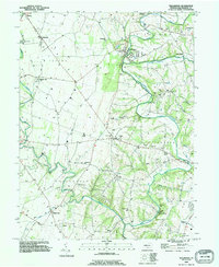
1990 Map of Williamson
USGS Topo · Published 1995About this map
Conococheague Creek and its west branch wind through this corner of Franklin County, defining a landscape of limestone features and deep-rooted agricultural communities. The presence of Baker Caverns and numerous Quarries reflects the underlying geology that supported early industry and land use. Small crossroads and hamlets like Williamson, Upton, and Welsh Run serve as anchors for the surrounding townships, including Peters and Antrim. Local heritage is well-preserved in the physical landmarks shown here, from the Martins Mill Covered Bridge to the many country congregations such as Macedonia Ch and Ebenezer Ch. The map also captures several private and community spaces, including the Enoch Brown Park and a distinct Landing Strip near the creek. This detail provides a clear view of the area before modern development altered the rural character of these historic Pennsylvania settlements.
Find a feature on this map
48 named features on this map. Tap any name to fly to it.
Don’t see what you’re looking for? This feature index may not catch every label — zoom into the map to look around manually.
Map Details
Editions of this 1990 Williamson Map
This is the sole edition of this map. No revisions or reprints were ever made.
Other maps of this area

1900 · Mercersburg
USGS Topo · 1:62,500

1902 · Chambersburg
USGS Topo · 1:62,500

1902 · Mercersburg
USGS Topo · 1:62,500

1909 · Hagerstown
USGS Topo · 1:48,000

1912 · Hagerstown
USGS Topo · 1:62,500

1912 · Williamsport
USGS Topo · 1:62,500

1942 · Hagerstown
USGS Topo · 1:125,000

1943 · Hagerstown
USGS Topo · 1:125,000

1943 · Mercersburg
USGS Topo · 1:24,000

1943 · Chambersburg
USGS Topo · 1:62,500
Featured Places
- Hamilton Township, PA
- Antrim Township, PA
- Williamson, St. Thomas Township
- Vanilla, Montgomery Township
- Rockdale, Peters Township