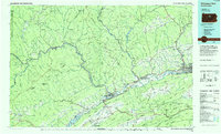
1984 Map of Williamsport West
USGS Topo · Published 1985About this map
The West Branch Susquehanna River carves a deep path through north-central Pennsylvania, anchoring a corridor of rail and industrial history. This mid-1980s landscape is defined by the heavy presence of Conrail lines following the river banks, connecting centers like Renovo and Lock Haven. On the southern edge of Lock Haven, Lock Haven State College and the Piper Memorial Airport stand as major local institutions, while the Cedar Hill Cem and St Marys Church offer specific points of interest for genealogical research. Massive tracts of public land, including the Sproul State Forest and Tiadaghton State Forest, dominate the high ridges. These forests protect the watersheds of the Sinnemahoning Creek and Kettle Creek, while Foster Joseph Sayers Lake and Bald Eagle State Park provide significant recreational infrastructure in the Bald Eagle Valley.
Find a feature on this map
145 named features on this map. Tap any name to fly to it.
Don’t see what you’re looking for? This feature index may not catch every label — zoom into the map to look around manually.
Map Details
Editions of this 1984 Williamsport West Map
2 editions found
Other maps of this area

1893 · Sunbury
USGS Topo · 1:62,500

1908 · Bellefonte
USGS Topo · 1:62,500

1909 · Bellefonte
USGS Topo · 1:62,500

1921 · Howard
USGS Topo · 1:48,000

1921 · Williamsport
USGS Topo · 1:48,000

1921 · Trout Run
USGS Topo · 1:62,500

1921 · Lock Haven
USGS Topo · 1:62,500

1922 · Philipsburg
USGS Topo · 1:62,500

1923 · Howard
USGS Topo · 1:62,500

1923 · Lock Haven
USGS Topo · 1:62,500
Featured Places
- Williamsport, PA
- Lock Haven, PA
- White Deer Township, PA
- Jersey Shore, PA
- Garden View, Old Lycoming Township