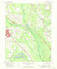
1966 Map of Williamstown
USGS Topo · Published 1968About this map
Williamstown and the surrounding South Jersey townships of Monroe and Waterford are captured here during a period of transition, where established rural crossroads meet the expanding suburban infrastructure of the mid-1960s. The Atlantic City Expressway and Black Horse Pike slice through the landscape, cutting across older patterns of movement defined by the Pennsylvania-Reading Seashore Lines. Local life is anchored by family and community institutions such as St James Ch, Hopewell Cem, and the Edgewood Regional High Sch.
Find a feature on this map
88 named features on this map. Tap any name to fly to it.
Don’t see what you’re looking for? This feature index may not catch every label — zoom into the map to look around manually.
Map Details
Editions of this 1966 Williamstown Map
Other maps of this area

1888 · Mount Holly
USGS Topo · 1:62,500

1890 · Hammonton
USGS Topo · 1:62,500

1890 · Glassboro
USGS Topo · 1:62,500

1891 · Philadelphia
USGS Topo · 1:62,500

1894 · Hammonton
USGS Topo · 1:62,500

1894 · Mount Holly
USGS Topo · 1:62,500

1894 · Philadelphia
USGS Topo · 1:62,500

1896 · Philadelphia
USGS Topo · 1:62,500

1898 · Glassboro
USGS Topo · 1:62,500

1898 · Philadelphia
USGS Topo · 1:62,500
Featured Places
- Sicklerville, Winslow Township
- Winslow Township, NJ
- Monroe Township, NJ
- Williamstown, Monroe Township
- Chesilhurst, NJ