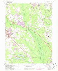
1966 Map of Williamstown
USGS Topo · Published 1982About this map
The Great Egg Harbor River carves a green corridor through this South Jersey landscape, anchoring the sprawling Winslow Wildlife Management Area. During the mid-1960s, the region balanced its agricultural and industrial roots with the rapid expansion of the Atlantic City Expressway, which bisects the quadrangle. The map reveals a dense network of smaller settlements like Blue Anchor, Cecil, and Sicklerville, each defined by local landmarks such as St Johns Ch or the Cecil Sch.
Find a feature on this map
95 named features on this map. Tap any name to fly to it.
Don’t see what you’re looking for? This feature index may not catch every label — zoom into the map to look around manually.
Map Details
Editions of this 1966 Williamstown Map
Other maps of this area

1888 · Mount Holly
USGS Topo · 1:62,500

1890 · Hammonton
USGS Topo · 1:62,500

1890 · Glassboro
USGS Topo · 1:62,500

1891 · Philadelphia
USGS Topo · 1:62,500

1894 · Hammonton
USGS Topo · 1:62,500

1894 · Mount Holly
USGS Topo · 1:62,500

1894 · Philadelphia
USGS Topo · 1:62,500

1896 · Philadelphia
USGS Topo · 1:62,500

1898 · Glassboro
USGS Topo · 1:62,500

1898 · Philadelphia
USGS Topo · 1:62,500
Featured Places
- Sicklerville, Winslow Township
- Winslow Township, NJ
- Monroe Township, NJ
- Williamstown, Monroe Township
- Chesilhurst, NJ