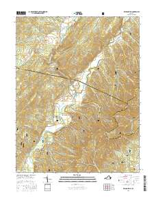
2016 Map of Williamsville
USGS Topo · Published 2016About this map
Williamsville and the southern edge of the Bullpasture Gorge define this landscape where the Bullpasture River joins the Cowpasture River. This mid-2010s survey captures the intersection of Highland, Bath, and Augusta Counties within the George Washington National Forest, a region characterized by deep drafts and steep ridgelines like Shenandoah Mountain. The settlement of Fort Lewis sits to the south near Ratcliff Hill, while the northern reaches include the hamlet of Patna along State Rte 614. Local water features such as Sinking Cr and the unique Water Sinks drainage illustrate the karst topography of the area. Family-named landmarks and distinct geographical points, including Byrd Point and Alum Rock, are clearly documented alongside rural routes like Hupman Valley Rd and Burnsville Rd.
Find a feature on this map
66 named features on this map. Tap any name to fly to it.
Don’t see what you’re looking for? This feature index may not catch every label — zoom into the map to look around manually.
Map Details
Editions of this 2016 Williamsville Map
This is the sole edition of this map. No revisions or reprints were ever made.
Other maps of this area

1894 · Staunton
USGS Topo · 1:125,000

1901 · Monterey
USGS Topo · 1:125,000

1924 · Mc Dowell
USGS Topo · 1:62,500

1941 · Monterey
USGS Topo · 1:62,500

1943 · Craigsville
USGS Topo · 1:62,500

1944 · Monterey
USGS Topo · 1:62,500

1944 · Mc Dowell
USGS Topo · 1:62,500

1945 · Craigsville
USGS Topo · 1:62,500

1946 · Mc Dowell
USGS Topo · 1:62,500

1946 · Williamsville
USGS Topo · 1:62,500