
1946 Map of Williamsville
USGS Topo · Published 1964About this map
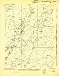
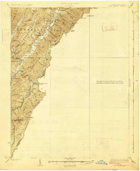
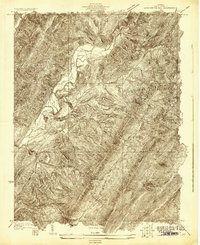
Williamsville and the winding Cowpasture River anchor this mid-century survey of the Appalachian Highlands. The landscape is defined by the heavy presence of the George Washington National Forest, where steep ridges like Little Valley Mountain and Shenandoah Mountain run in parallel ranks. Settlement is largely confined to the narrow river valleys and gaps, marked by a high density of small community landmarks including Lockridge Memorial Ch, Starr Chapel, and the Flood Sch. High elevation observation is noted by the Duncan Knob Lookout Tower and Wallace Peak Lookout Tower, reflecting a period when fire detection was critical for timber management. The map also captures several rural crossroads and camps, such as Bath Alum Camp and Burnsville, providing a detailed look at the social geography of Bath and Highland counties before modern infrastructure altered these mountain corridors.
Find a feature on this map
127 named features on this map. Tap any name to fly to it.
Don’t see what you’re looking for? This feature index may not catch every label — zoom into the map to look around manually.
Map Details
Editions of this 1946 Williamsville Map
This is the sole edition of this map. No revisions or reprints were ever made.
Other maps of this area

1894 · Staunton
USGS Topo · 1:125,000

1894 · Natural Bridge
USGS Topo · 1:125,000

1894 · Lexington
USGS Topo · 1:125,000

1901 · Monterey
USGS Topo · 1:125,000
1922 · Cass
USGS Topo · 1:48,000
1923 · Warm Springs
USGS Topo · 1:48,000
1924 · Cass
USGS Topo · 1:62,500
1924 · Mc Dowell
USGS Topo · 1:62,500
1926 · Warm Springs
USGS Topo · 1:62,500
1930 · Warm Springs Run
USGS Topo · 1:24,000