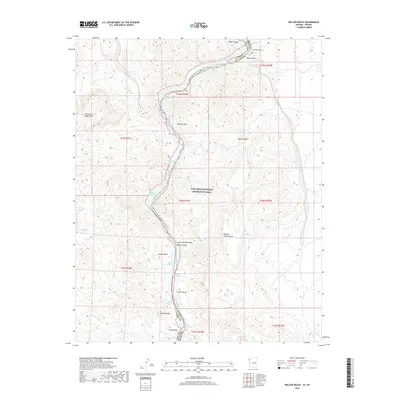
2018 Map of Willow Beach
USGS Topo · Published 2018About this map
Willow Beach serves as a focal point along the Colorado River within the Lake Mead National Recreation Area, where the river carves through Black Canyon. This 2018 survey details a complex riparian corridor defined by the Black Canyon National Water Trail, winding past distinctive landmarks such as Monkey Rock and the high elevations of the Eldorado Mountains. The landscape is characterized by numerous river-level coves and washes, including Painted Cove, Nevada Sheep Cove, and Malpais Wash, which drain the surrounding desert uplands. The mapping of Roaring Rapids and Shallow Rapids indicates the varied river morphology below the canyon walls. Further south, the terrain rises toward Squaw Peaks and the Chalk Cliffs, illustrating the vertical relief between the riverbed and the Mojave Desert plateaus like Malpais Flattop Mesa.
Find a feature on this map
44 named features on this map. Tap any name to fly to it.
Don’t see what you’re looking for? This feature index may not catch every label — zoom into the map to look around manually.
Map Details
Editions of this 2018 Willow Beach Map
This is the sole edition of this map. No revisions or reprints were ever made.
Other maps of this area

1886 · Camp Mohave
USGS Topo · 1:250,000

1892 · Camp Mohave
USGS Topo · 1:250,000

1926 · Nelson
USGS Topo · 1:96,000

1942 · Camp Mohave
USGS Topo · 1:250,000

1947 · Kingman
USGS Topo · 1:250,000

1948 · Kingman
USGS Topo · 1:250,000

1954 · Kingman
USGS Topo · 1:250,000

1955 · Kingman
USGS Topo · 1:250,000

1958 · Kingman
USGS Topo · 1:250,000
1958 · Nelson
USGS Topo · 1:62,500