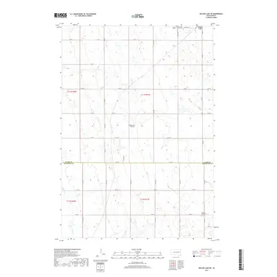
2017 Map of Willow Lake SW
USGS Topo · Published 2017About this map
Coteau des Prairies, a vast glacial upland, dominates this landscape in eastern South Dakota at the junction of the Clark Co and Kingsbury Co line. The map highlights the rural township structure of the early 21st century, punctuated by a series of small water bodies and seasonal wetlands characteristic of the prairie pothole region. In the northeast corner, the settlement of Willow Lake serves as the local hub, while the surrounding sections preserve early community sites like the German Presbyterian Cem and Saint James Catholic Cem. Redstone Cr meanders through the southwestern corner, reflecting the natural drainage patterns that have historically shaped agriculture in these townships. The intricate grid of section roads, including Co Rd 38 and 429th Ave, reveals the persistent late-19th-century land division system still in active use.
Find a feature on this map
38 named features on this map. Tap any name to fly to it.
Don’t see what you’re looking for? This feature index may not catch every label — zoom into the map to look around manually.
Map Details
Editions of this 2017 Willow Lake SW Map
This is the sole edition of this map. No revisions or reprints were ever made.
Other maps of this area

1899 · De Smet
USGS Topo · 1:125,000

1953 · Watertown
USGS Topo · 1:250,000

1958 · Watertown
USGS Topo · 1:250,000

1971 · Bancroft East
USGS Topo · 1:24,000

1971 · De Smet
USGS Topo · 1:24,000

1971 · Bancroft West
USGS Topo · 1:24,000

1973 · Carpenter SE
USGS Topo · 1:24,000

1973 · Willow Lake
USGS Topo · 1:24,000

1973 · Vienna West
USGS Topo · 1:24,000
1973 · Cherry Lake
USGS Topo · 1:24,000