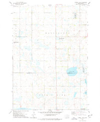
1973 Map of Willow Lake
USGS Topo · Published 1978About this map
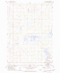
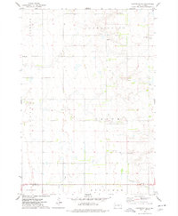
Willow Lake and its eponymous settlement anchor this eastern South Dakota landscape during the early 1970s. The town site is characterized by its proximity to the B N railroad line and a small Landing Field, reflecting a community integrated with mid-century transit and agricultural logistics. The surrounding plains of Darlington and Merton townships are defined by a complex network of wetlands and conservation lands, including the Dry Lake No 2 State Public Shooting Area and the National Waterfowl Production Area. For local historians and genealogists, the map preserves the locations of rural landmarks such as West Merton Cem, Good Hope Ch, and a central Townhall. The presence of numerous Gravel Pits and the winding course of Pearl Cr illustrate the practical intersection of natural drainage and local industry in Clark County.
Find a feature on this map
23 named features on this map. Tap any name to fly to it.
Don’t see what you’re looking for? This feature index may not catch every label — zoom into the map to look around manually.
Map Details
Editions of this 1973 Willow Lake Map
This is the sole edition of this map. No revisions or reprints were ever made.
Other maps of this area

1953 · Watertown
USGS Topo · 1:250,000

1958 · Watertown
USGS Topo · 1:250,000
1973 · Carpenter SE
USGS Topo · 1:24,000
1973 · Clark South
USGS Topo · 1:24,000
1973 · Vienna West
USGS Topo · 1:24,000
1973 · Cherry Lake
USGS Topo · 1:24,000
1973 · Naples
USGS Topo · 1:24,000
1973 · Willow Lake SW
USGS Topo · 1:24,000
1973 · Raymond SE
USGS Topo · 1:24,000
1973 · Carpenter NE
USGS Topo · 1:24,000