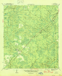
1946 Map of Wilma
USGS Topo · Published 1946About this map
The Apalachicola National Forest dominates this mid-century survey of Liberty County, revealing a landscape defined by expansive wetlands and isolated outposts. The Apalachicola Northern railroad cuts a straight diagonal through the terrain, serving as the primary corridor for small settlements like Wilma and Vilas. These sites, along with the Ranger Sta and the prominent Wilma Firetower, highlight the area's importance to Florida's timber and forest management history during the 1940s.
Find a feature on this map
29 named features on this map. Tap any name to fly to it.
Don’t see what you’re looking for? This feature index may not catch every label — zoom into the map to look around manually.
Map Details
Editions of this 1946 Wilma Map
3 editions found
Other maps of this area

1944 · Queens Bay
USGS Topo · 1:24,000

1945 · Kennedy Creek
USGS Topo · 1:31,680

1945 · Estiffanulga
USGS Topo · 1:31,680

1945 · Orange
USGS Topo · 1:31,680

1945 · Woods
USGS Topo · 1:31,680

1945 · Telogia
USGS Topo · 1:24,000

1946 · Queens Bay
USGS Topo · 1:31,680

1946 · Sumatra
USGS Topo · 1:31,680

1946 · Telogia
USGS Topo · 1:31,680

1946 · Owens Bridge
USGS Topo · 1:31,680